Today, Interior Secretary Ken Salazar doubled down on the Obama Administration’s previous offshore drilling moratorium announced in March 2010, by placing EVEN MORE of the Outer Continental Shelf (OCS) off limits to energy development.
As the maps below illustrate, the Obama Administration has moved our country backwards in terms of offshore land available for energy leasing. In 2008, there was bipartisan support to lift the Congressional drilling moratorium, now just two years later, the Administration has unilaterally re-imposed the ban.
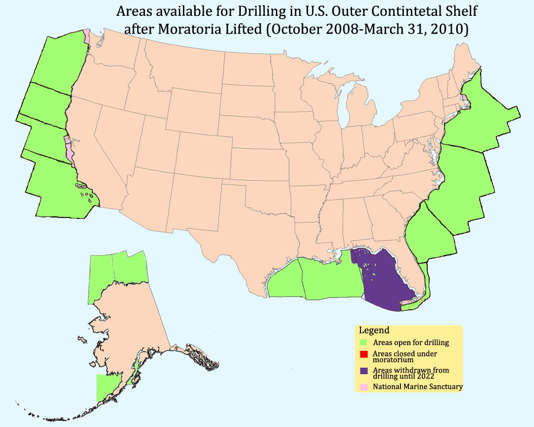
Map of OCS when President Obama took Office - January 2009
Click to enlarge map
- In 2008, facing record gas prices, Congress and President Bush both announced an end to the decades-long ban on offshore drilling. This opened 500 million additional acres for new energy production that contain an estimated 14 billion barrels of oil and 55 trillion cubic feet of natural gas.
- After the moratoria were lifted, the Bush Administration issued a 2010-2015 OCS leasing plan, and solicited comments on all aspects of the plan. The proposal included 31 OCS lease sales in all or some portion of the 12 of the 26 planning areas—4 areas off Alaska, 2 areas off the Pacific coast, 3 areas in the Gulf of Mexico, and 3 areas off the Atlantic coast.
Map of OCS after President Announced New Drilling Plan - April 2010
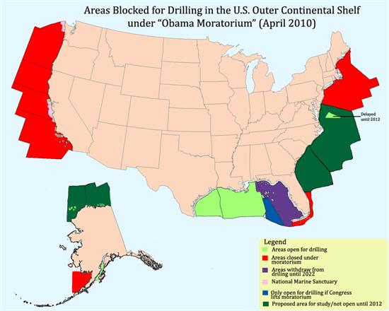
Click to enlarge map
- Under the plan announced by President Obama in April 2010, the majority of the areas open for drilling once the moratoria were lifted were once again closed. This included all of the Pacific Coast, the Northeastern Atlantic and Bristol Bay in Alaska.
- In total, the Obama OCS plan puts 13.14 billion barrels of oil and 41.49 trillion cubic feet of natural gas under lock and key.
- The Administration only considered development of the Mid-Atlantic, Southern Atlantic, Chukchi and Beaufort Sea following Draft Environmental Study work to be conducted over the next year.
- The Administration would allow drilling in a portion of the Eastern Gulf of Mexico if Congress lifted the ban that is in place until 2022.
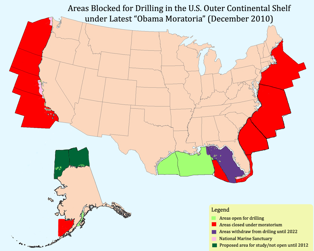
Map of OCS after Administration Announced Latest Drilling Plan - December 2010
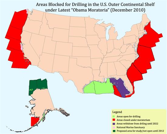
Click to enlarge map
- President Obama’s latest and most restrictive OCS leasing plan now places the entire Pacific, the entire Atlantic and the Eastern Gulf off limits to future energy production – as it was under the Congressional moratorium.
- This puts some of the most promising shallow water resources in the world off-limits and pushes domestic oil development into a smaller fraction of the Gulf of Mexico and into deeper water.
- Previous lease sales off the coast of Virginia, scheduled to take place in 2011, are on hold until after 2017.
- In Alaska, there is only the potential for lease sales in the Beaufort, Chukchi, and Cook Inlet planning areas before 2017.
- The American Petroleum Institute estimates today’s announcement will cost: 75,000 jobs; $91 billion in cumulative government revenues (royalties, severance taxes, property taxes, income taxes, lease bonuses); 900,000 bbls oil/day; and 2.9 tcf natural gas/day.
# # #
Print version of this document